Editor’s Note: This is the second piece of RIEGL’s two-part article describing Euclideon’s easy to use, free, web-based platform, and case studies showing how it was used on Orion projects.

How an Innovative Australian Survey Firm, Orion Spatial Solutions, Used Euclideon’s “udStream” to Store, Share and Work With Big 3D Data on an Urban Transportation System Continuing Contract and Historical Rail Digital-Twin October 2020
In Part 1 of this article (which can be found on the RIEGL Internationl Newsroom) we introduced Euclideon’s udStream platform and presented a case study on a mining project in Australia where LiDAR was collected above ground, and merged with underground data to create a complete base map.
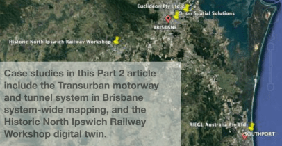
In Part 2 below you will find case studies for the
Brisbane Urban Motorway and Tunnel System, and
the Historic Rail Station Workshops Digital Twin.
Orion Case Study #1 – Brisbane Urban Motorway and Tunnel System Project Location: Brisbane, QLD, Australia
Client: Design Teams for Transurban (Owner)
Date: Ongoing
Description: The owner and designer of this active urban toll road and tunnel network have an ongoing need for high accuracy, information-rich 3D datasets. The point clouds can be used for asset inventory, asset management, condition assessments, repair / upgrade / expansion designs, and construction compliance. The transportation network includes 38 km of tunnels (some2-and30lane), and approximately 100 km of multi-lane motorway in Brisbane.
Challenge on the Transurban Project:
-Limited Access. The network operates 24/7. This means Orion must perform most of their scans at low traffic times (middle of the night), or during short maintenance shutdowns, using RIEGL LiDAR scanners and ground survey.

-Physical Obstacles. The system is continuously changing due to maintenance, repairs, upgrades and expansions, so there are a lot of obstacles to work around when performing data collects such as heavy equipment like boom lifts and cranes.
-Getting Location Info in Tunnels. GNSS in the tunnels was a bit of a challenge, so Orion’s team found a solution. Philipp said “The project had a significant amount of GNSS denied areas in the tunnels and portals, so we chose to go with our vehicle mounted, RIEGL VZ-400 scanners and use a stop and-go methodology. This also gave us the most flexibility with the control placement and interface with other work crews.”
–Massive Amounts of Data. This amount of data can be hard to manage, and the Orion team determined that Euclideon’s udStream
would provide an ideal platform to help the design team collaborate with the owner in 3D, and in near-real time.

Data Collection Tools
–RIEGL VZ-400 with Nikon Camera and
GNSS where possible
-Vehicle mounted scanning for stop-and-go collects every 20-30 meters – 10.5 KM in each direction – road and tunnel
About the Transurban Project
Transurban is a large, publicly traded road operator that develops and manages urban user-financed transportation networks primarily in Australia, with other facilities in Washington, DC, USA and Montreal, Canada. Their business model is basically working with various government entities to design, build, maintain, finance and operate a major roadway and/or tunnel for an agreed-upon period of time – usually decades. This is helpful to public transportation agencies who may be cash strapped or want to allocate their liquid funds for other governmental programs.

Companies like Transurban take on much of the risk
of large infrastructure projects to help communities meet capacity needs. In return for accepting this risk, companies like Transurban are given concessionaire rights, with the hope that they will collect enough in toll revenue to offset their expenses and earn a profit. Because these toll facilities are also a public asset, Transurban is contractually bound to provide travelers with a very high level of service. Moreover, the traveling public must see a benefit to using the toll routes, otherwise they simply won’t use them. Therefore, it is imperative that organizations like Transurban keep the motorways and tunnels in excellent repair, safe to travel on, and with freely moving traffic.
Orion is part of the team that supports that ongoing effort – to provide a high level of quality and service to the traveling public. Their role is to
provide ongoing LiDAR and traditional survey as required.
Orion’s John Philipp said, “There is a lot of maintenance and expansion of the system underway at any given time, with a fair number of tunnels going into Brisbane.” He continued, “Collecting the high accuracy, quick turnaround data that the designers need would not be possible on this busy system without modern tools like the RIEGL scanners.”

On a typical job, Orion has a field team traversing
and laying first order control. Then Orion’s mobile LiDAR scanning teams work nights to perform the scans using the RIEGL VZ-400 terrestrial laser scanners, or the VUX-1UAV scanners mounted rooftop on their company trucks. Imagery is important too, and that is collected as part of each LiDAR scan and is automatically synced with the RIEGL LiDAR scans.
Once the point cloud data and images are collected
and checked, the information can be uploaded onto
udStream and shared with the design team via a
link. “The ability to store, view and work with these
complex point clouds on udStream is really a game
changer. We can turn projects around faster than
ever, and give more and better information to the
team,” said Philipp.

David Hedgcock, Managing Director of Orion added,
“Designers can use udStream to consider different design scenarios and quickly see how one design change might affect other parts of the network.” He continued, “Team members can perform all kinds of measurements with ease, and quantify things like fill dirt or pavement thicknesses down to the millimeter. Another big plus is that udStream allows all parties to look at the same view simultaneously, and from wherever they are.”
From data collection to virtual site visits in 3D, there
is no need to shut down the road. This makes for an
infinitely safer, faster, and more accurate way to
conduct the work. Orion leadership agrees that these tools increase the value of the survey information. Philipp said, “LiDAR point-clouds are easily
viewed and updated digitally, rather than on large rolls of paper.” He added, “Our intent was to demonstrate these tools to different members of the design team and Transurban, and help them to see what is possible.”


Case Study #2 – Historic Rail Station Workshops Digital Twin
Project Location: North Ipswich Railway Workshop, Ipswich, Queensland, Australia
Client: Extent Heritage Pty Ltd with Queensland Rail Limited
Date: August 2019
Project Description: The North Ipswich Railway Workshops complex is one of the most important rail-related heritage sites in Queensland and is listed on the Queensland Heritage Register. The property operator, Queensland Rail, wanted a record of this century old site. It was important that the entirety of the historic features including the buildings and workshops (interior, exterior, machinery, equipment and other contents) were thoroughly recorded in a manner that provides a platform for their future
interpretation.
Extent Heritage Pty Ltd served as a heritage consultant to create the archival record of the site and its contents. Orion served on the selected team and performed ground and airborne LiDAR scanning, photogrammetry and traditional survey. The datasets were then imported into Euclideon’s udStream as the core part of the deliverable.
Challenges on the Historic Rail Digital Twin
Project:

-Short Project Schedule and Limited Access.
The work needed to be completed as quickly as
possible so as not to interfere with operations.
-Merging of data from different Methodologies. The work would require
merging of data from different types of collections including LiDAR, imagery and meta-data. Scans were to include intensity and color views, at a minimum of 3 mm at 10 m. Extent Heritage Pty Ltd specified the use of high definition surveying (HDS), photogrammetry, and virtual/augmented reality (VR/AR). These data sets would need to be merged seamlessly and in a high quality manner.
-High Quality, Easily Accessed 3D Visual Content Was a Must. The team’s deliverable had to provide a “virtual” experience that is visually pleasing, uncomplicated, interactive and immersive. The udStream allows the multiple viewers to move in any direction throughout the tours, using no specialized equipment.
-Ground and Airborne Collections Were Required. Roof structures and aerial views were needed, necessitating the use of airborne LiDAR and photogrammetry.
-Compliance with Governing Agencies. The methodology used in the archival records had to meet principles established by numerous agencies including: The Burra Charter: The Australia ICOMOS Charter for Places of Cultural Significance (Burra Charter), 2013; the ICOMOS Charter for the Interpretation and Presentation of Cultural Heritage Sites (Ename Charter), 2008; and Guideline: Archival Recording of Heritage Places of the Queensland Heritage Act 1992.
-Tight Budget. Orion had to come in at or under the agreed upon fee Extent committed to in their proposal.

Data Collection Tools: (exteriors only)
–RIEGL Terrestrial Laser Scanner (TLS) VZ-400
-Helicopter with RIEGL VUX-1UAV
About the Historical Rail Digital Twin Project
The project scope was to document extensive historic rail facilities that are
among the oldest and most treasured in the country, with some structures that date back to the 1800’s. The data collection also included the steam rail
equipment and blacksmith workshops, which are arguably the best preserved in the country.
In the past a documentarian would take photographs and videotape the area, adding to these their extensive notes. Euclideon’s udStream offered a more modern solution that would make the data easily viewed, interactive and would require no additional investment in software or equipment to view the colorful and precise 3D data. The team combined the latest in LiDAR, photogrammetry and AR/VR technology to create a digital twin never seen before by Queensland Rail.
With the data collected by Orion, the team provides an immersive experience for future generations to view buildings and objects in full color, and within millimeter accuracy in any optical direction. This data will likely be the basis of future museum-style experiences, documentaries, further studies, and also viewed as-is on udStream by rail enthusiasts
around the world.

John Philipp said, “The key to this project was a high quality survey. With what we produced and
uploaded onto udStream,
historians will be able to reconstruct the buildings should they desire, find
replacement parts, and document what was there over a hundred years ago. This same workflow
can and is being used to capture other historical treasures like cultural indigenous sites such as
burial sites, sacred gathering areas.”
Euclideon and Orion wanted to demonstrate to
the historians and the people at Queensland Rail
what could be done with the combined RIEGL
and Euclideon udStream technologies, and how
easy and beneficial it would be to do more
projects like it.
The initial phase is complete and has been received well by all parties. This is an enormous facility and there is still much more work to be performed.
Orion and RIEGL Australia “Feedback Loop” Benefits Clients
RIEGL Australia and Orion Spatial Solutions are both located in South East Queensland, Australia. Over the years, leadership from the two companies have had many in-depth discussions about the market demands for scanning hardware, software and data deliverables. These ongoing conversations provide invaluable user feedback that often finds its way to the RIEGL engineering team in Austria.
Glenne Blyth, Managing Director of RIEGL Australia said, “In-depth meetings with end users like John Philipp at Orion and others like him, has naturally morphed into a sort of ‘feedback loop’ between Australia and Austria. By sharing information we have been able to do some problem-solving together, and also anticipate what types of future product developments would be helpful in the field.”
Orion has grown in size and capabilities with the addition of new RIEGL technology, including the VUX-1UAV in 2020. Blyth added, “The teams at Orion are absolute professionals at what they do and how they deliver their projects. And because of the strong relationship we’ve developed over years – between manufacturer and end-user – Orion gets the most out of their RIEGL products. They need only pick up the phone or send an email when they are approaching a challenging project. We both benefit so
much from these conversations, but the big winner is their clients.”

RIEGL introduced Orion to Euclideon, also in Queensland, several years ago as a possible solution to their specific needs for managing the large, 3D datasets. This introduction helped their data go full circle – from precision data collection to delivering useful products to their clients like they’ve never experienced before. It’s impossible to put a price on the connections and sharing of information – from project beginning to end.
Summary
Orion Spatial Solutions, using the RIEGL terrestrial and airborne (UAV and manned) LiDAR scanners combined with Euclideon’s udStream, is setting new standards with their clients. They are performing the onsite collections quickly and getting highly accurate data that clients find useful in a myriad of ways.
On the back end of the deliverable, Euclideon developers have been eager to work hand in hand with companies like Orion to present the final deliverables in a format that end users can easily work with and afford. This next step of combining multiple, big, information-rich datasets in an easy to store/use/share format is a major step forward in the evolution of the 3D industry.
“With Orion capturing a massive amount of data with their bathymetry, terrestrial, mobile and airborne RIEGL scanners, udStream will be a fundamental part of the toolkit moving forward. We look forward to seeing the platform grow,” said Orion’s John Philipp.
To view Part 2 and Part 1 in PDF format, please click the link below:
Part 2
Part 1
CONTACTS for more information:

About RIEGL:
RIEGL is an international leading provider of cutting-edge technology in airborne, mobile, terrestrial, industrial and unmanned laser scanning solutions.
RIEGL has been producing LiDAR systems commercially for over 40 years and focuses on pulsed time-of-flight laser radar technology in multiple wavelengths.
RIEGL’s core Smart-Waveform technologies provide pure digital LiDAR signal processing, unique methodologies for resolving range ambiguities, multiple targets per laser shots, optimum distribution of measurements, calibrated amplitudes and reflectance estimates, as well as the seamless integration and calibration of systems.
RIEGL’s Ultimate LiDARTM 3D scanners offer a wide array of performance characteristics and serve as a platform for continuing Innovation in 3D for the LiDAR industry.
From the first inquiry, to purchase and integration of the system, as well as training and support, RIEGL maintains an outstanding history of reliability and support to their customers.
Worldwide sales, training, support and services are delivered from RIEGL’s headquarters in Austria; main offices in the USA, Japan, China, Australia and Canada; and a worldwide network of representatives.