
In four short years the company has been able to demonstrate with certainty the value of RIEGL’s full-waveform LiDAR over conventional survey methods in this lush, densely vegetated country.
June 2021
Introduction
AB Surveying and Development’s (ABSD) founder and professional engineer/surveyor, Tony Botor, was excited enough about LiDAR technology back in 2016 that he began actively seeking out more information. Having used a lower end LiDAR scanner that was designed for architectural as-built documentation projects, he knew he was on to something with this technology for much larger applications. He knew he had only scratched the surface – he could do more with LiDAR if he had the right tools.
At that time, aside from a handful of professors at the University of the Philippines, rarely was anyone in the area familiar with LiDAR. So Mr. Botor began a worldwide search for a LiDAR tool that would reliably allow his survey crews to obtain very precise data over a wider geographical area. He hoped this same technology would allow him to get better survey data in areas with thick vegetation, a major challenge in the islands of the Philippines.
Mr. Botor’s research led him to the RIEGL line of scanning systems and he soon contacted them to learn more. He thought that if the RIEGL full-waveform LiDAR scanners worked as described – collecting long-range 3D point clouds with the ability to view through heavy vegetation all the way to bare earth – this would revolutionize the way survey was performed in the Philippines. The right tools would allow his crews to give their clients more useful data than they had received before, and in a fraction of the time.

RIEGL connected Mr. Botor to their nearby distribution partner, Mr. CS Lim at GPS Lands in Malaysia. Mr. Lim helped ABSD acquire their first RIEGL scanner, the airborne VUX-1LR.
The VUX-1LR was in the final stages of production at that time, and Mr. Botor was one of the first to purchase this model. ABSD’s experience with the RIEGL airborne sensor was excellent, as expected.
Now there was one more obstacle to success: convincing his company’s many government and private clients that this technology could be of great value to them, and that the better data and time savings would be worth the upfront cost.
CLICK HERE for 2-Minute Video Showing ABSD LiDAR Output Examples


Convincing Clients to Consider LiDAR
Surveyors in the Philippines have used conventional methods for many years, and they have a level of comfort in knowing what end product they can expect, how long it will take, and how much a survey is likely to cost. It’s understandable that ABSD’s clients would question if the LiDAR technology would really be able to meet all their needs and also be affordable. These unknowns made clients hesitant to take a chance.
Further, moving into the world of LiDAR and 3D is an evolution that affects many aspects of a design and construction team’s workflow, and clients were unsure about how to make that shift. Mr. Botor and his LiDAR specialists knew they had to prove the technology and demonstrate to their clients how they could work with the data.

Jian Botor, son of Tony, was challenged with a new task: do whatever he could to prove to their clients that the RIEGL LiDAR full-waveform technology can become their preferred method of survey on many types of projects.
ABSD set about to identify projects that seemed perfect for using LiDAR, but where the client had requested traditional survey. Jian said, In order to prove the technology we offered to perform the LiDAR work for free, and then if the clients liked the data they would pay us. This was a way for ABSD’s clients to experience the value of the data without any risk whatsoever. We began demonstrating the LiDAR obtained with the VUX-1LR. To give clients assurance in the accuracy of the 3D LiDAR data we performed survey validation with conventional methods.
He continued, Because the data was delivered so quickly, was far superior in quality, and was easy for the clients to utilize, it has taken a short time – only a few years – for them to adapt to new methods. Many of our clients now request their surveys be performed only as LiDAR, and more frequently now they specify their requests for proposals that way.


LiDAR Standards and Guidelines are Being Developed
In the Philippines, as with many countries, the evolution of acceptance of LiDAR begins with industry leaders having a few good experiences with the technology.
With increased use of LiDAR, the procurement process is becoming more formalized. In time, more and more procuring parties will establish their own standards and guidelines, and specify that future projects of a certain size and type will be performed using the 3D, paperless technology that LiDAR provides.
Tony, Jian and others are collaborating with the Philippines Survey Association to explore the best ways to establish standards to ensure that lower quality data is not accepted on projects in the cases where precision is vital and better survey technology is readily available.
What Types of Equipment is ABSD Using?
ABSD began introducing LiDAR on its projects with the RIEGL VUX-1LR, and because of their early successes they have continued to add to their portfolio of scanners. They have since purchased the RIEGL VUX-240 and the terrestrial laser, the VMZ-2000. Jian said, We can mount the VUX scanners on helicopters. This platform allows us to confidently gather data quickly. The scanner is an expensive piece of equipment, so we don’t want to lose it because a drone lost its GPS (global positioning satellite) signal, for instance. Using a helicopter is a little more expensive but removes risk and we can control the collection better in all weather conditions.
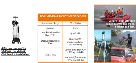
He continued, Our RIEGL VMZ-2000 is a scanner that we have used on the tripod or mounted on a ground or water vehicle. It scans out into the distance very far and is another good option in many situations.

ABSD’s Demonstration Projects on Actual Projects Prove the Technology
ABSD was able to demonstrate the LiDAR technology in this no-risk way many times over to their clients. Below is of bit of information on two actual LiDAR demonstrations:
DEMONSTRATION EXAMPLE #1
Land Development Project for Makati Development Corporation (MDC)
When ABSD acquired the their first LiDAR scanner, the VUX-1LR, no one would believe it was possible to provide such accurate and precise data so quickly. To demonstrate the 3D deliverables that were possible, Jian asked one of the prominent developers there, Makati Development Corporation, to allow them to scan one of their upcoming project sites. MDC is a large construction company that specializes in land development for large-scale housing subdivisions, corporate office buildings and other large new projects.
Jian said, They were not really keen on getting LiDAR, but I told them that if they would permit us to simply fly over their project area, we would create at our own expense a 3D map from LiDAR. They could then compare it to the map they had produced using conventional survey. He continued, I told them that we simply wanted to prove that we could quickly produce a map that would be more accurate and detailed than they were used to receiving. They agreed, and we scanned a large area where development was planned. Within weeks we provided the 3D map and superimposed it over the conventional map. The MDC team was impressed. In fact they were able to see some streams that were not reflected on the conventional survey, but these features showed clearly on the LiDAR map. This information was highly useful.
This exercise proved to MDC that on a heavily vegetated project site we would be able to see more than a traditional surveyor could. Jian said, In conventional surveys of large, vegetated areas a surveyor may skip some areas because they are difficult to access, but the LiDAR instrument would show everything. MDC was able to work with much better data using the LiDAR – more than they thought was possible. MDC has now fully accepted the technology, and has made our LiDAR scans part of their workflow on future projects.
DEMONSTRATION EXAMPLE #2
Aerial LiDAR Mapping of the Entire City of Baguio
The City of Baguio, located in a highly urbanized mountainous location, became the first local government in the Philippines to have its entire 5,750 hectare area surveyed using LiDAR. They needed a detailed and precise base map tool for flood mapping, updated tax mapping, design of upgrades to existing roads, future urban development, and disaster risk mitigation.
Jian said, We made a presentation to the City leadership and showed them some of our previous projects performed with LiDAR. We held subsequent meetings with them to discuss this technology in greater detail and to answer their questions. ABSD was the only survey company here who could do the work with LiDAR. When the City released their formal request for survey we responded and competed with traditional survey companies.
Happily, we were awarded the assignment and when we initiated the project we offered to go one step further, and prove the data accuracy with joint validation of the traditional survey data. The project was a big success and ABSD provided the City with survey-grade maps, aerial photos, digital surface and terrain models (DSM-DTM), topographic and waters map, and as-built maps of all the buildings and infrastructure.
This demonstration provided the City with a state-of-the-art decision-making tool for city-wide planning and development, said Tony Botor.

The entire mapping of the City of Baguio only took two days and another three weeks of post fieldwork processing through this technology, a feat that would have been unimaginable if we are still using conventional surveying methods.
#END#
To view this article in PDF format, click the link below.
AB Surveying and Development (ABSD) Introduces LiDAR in the Island Nation of the Philippines

About ABSD
AB Surveying and Development is considered one of the top ten survey companies in the Philippines. The company is headquartered in Manilla, and employs a staff of approximately 130 LiDAR and conventional surveyors, engineers, specialists and support staff. Tony Botor was a founding member of the company back in 1992 when it was originally called Geosystems Surveying Development. Today ABSD works with public and private clients on a wide range of transportation, energy, land development and other large-scale assignments.
CONTACT: AB Surveying and Development, Jian Botor, LiDAR Engineering Leader, +632 728 0260 jian.botor@absurveyingph.net | www.absurveyingph.net

About GPS Lands
GPS Lands is the authorized distributor for RIEGL Laser Measurement Systems GmbH in Malaysia, Singapore, Indonesia, Philippines, Thailand and Vietnam.
Founded in 2000, GPS Lands is a leading Geospatial and Mapping Technologies solution provider in the ASEAN region.
CONTACT: GPS Lands, a RIEGL Distributor Partner. CS Lim, +603-5192-0588, cslim@gpslands.com.my | www.gpslands.com.my
About RIEGL
RIEGL is an international leading provider of cutting-edge technology in airborne, mobile, terrestrial, industrial and unmanned laser scanning solutions.
RIEGL has been producing LiDAR systems commercially for over 40 years and focuses on pulsed time-of-flight laser radar technology in multiple wavelengths.
RIEGL’s core technology, the digitization of LiDAR signals (“Waveform LiDAR”), provides unique methodologies for resolving range ambiguities, multiple targets per laser shots, optimum distribution of measurements, calibrated amplitudes and reflectance estimates, as well as the seamless integration and calibration of systems.
RIEGL’s Ultimate LiDARTM 3D scanners offer a wide array of performance characteristics and serve as a platform for continuing Innovation in 3D for the LiDAR industry.
From the first inquiry, to purchase and integration of the system, as well as training and support, RIEGL maintains an outstanding history of reliability and support to their customers.
Worldwide sales, training, support and services are delivered from RIEGL’s headquarters in Austria; main offices in the USA, Japan, China, Australia, UK and Canada; and a worldwide network of representatives.
CONTACT: RIEGL ASIA PACIFIC, Marcos Garcia, Business Development Manager | mgarcia@riegl.asia | www.riegl.com