Editors Note: LiDAR News featured a new article with David Headrick from KCI Technologies, Inc, a RIEGL mobile user. Headrick has been very busy lately with his RIEGL VMX-2HA as he works on scanning everywhere from the Pennsylvania Turnpike to Tampa Electric Company power corridors. Please enjoy the article below:

David Headrick (KCI Technologies, Inc.) certainly has a unique perspective on advanced surveying technologies. David started his career in traditional surveying, but after the Internet Bubble collapsed, he went to law school and practiced construction law for several years. In 2012, Tate Jones, owner of LandAir Surveying (since acquired by KCI) lured him back into the business. Now, David serves in a unique role as business developer, project manager, and general counsel.
Through managing projects and business development, David has become a subject matter expert on advanced surveying technologies. He frequently speaks at conferences, events, and organizations about 3D laser scanning, mobile/aerial, LiDAR, drones, BIM, and augmented/virtual reality. In case that is not interesting enough, he will also do live demonstrations with drones, virtual reality goggles, digital twin BIMs, and augmented reality vGIS tablets. “These technologies are not isolated, and we are combining them in groundbreaking ways. Just a couple of years ago, nobody would believe that we can produce 5 mm “topo maps” for floor flatness or produce augmented reality visualizations that are so convincing,” David says.
I wanted to get David talking about some of the more interesting projects that he has managed. Turns out, just about every conceivable project type is in his wheelhouse, including scanning for architecture and engineering design, SUE, construction verification, clash detection, and asset management. David says, “We’ve got all the right tools and workflows, whether it’s for transportation or industrial engineering or even historic preservation. Technology has transformed the world of surveying and created a revolution in 3D data capture.”
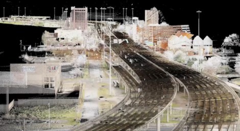
One tool of particular interest is KCI’s new RIEGL VMX-2HA mobile lidar unit. This is RIEGL’s top of the line mobile scanner and KCI is completing projects with it around the country. David says, “There was a bit of a learning curve in the beginning, but with RIEGL’s support, we have scanned projects everywhere from the Pennsylvania Turnpike to Tampa Electric Company power corridors. The capabilities are impressive. The VMX-2HA can collect 2 million points per second, meaning 3,000 points per square meter while driving 75 mph and as many spherical photos through the Ladybug camera as you want.”
One recent mobile LiDAR project entailed scanning 26 miles along the Pennsylvania Turnpike to as-built utility corridors along the roadway. Because this area of the Turnpike had two lanes, KCI ultimately turned over 52 miles of 100’ wide utility corridor as-builts. “Our client used the as-built data to locate existing poles and plan for the installation of overhead fiber optic lines. The VMX-2HA provided outstanding coverage and data quality. Plus, since the unit has nine high-definition cameras on board, it really brings the project area back into the office. We were able to drive the project in two days and then turn around the as-built data within a week of receiving the survey control network.”

Another project that David mentioned really seemed to stand out from the others, encompassing many of these 3D technologies. David managed the mapping and clash detection of the I-59/I-20 corridor going through Birmingham’s Central Business District (CBD). Known locally as “Malfunction Junction,” the Alabama DOT set the lofty goal of replacing 15 miles of roadway converging and running through downtown Birmingham, all within 14 months. At $750 million, it was the largest construction project in Birmingham’s history. Compounding the complexity, the project included 36 bridges over 7 linear miles.

ALDOT tasked David’s team with coordinating the mapping, modeling, and clash detection effort. David told me that, “LiDAR was the star of the show! We used helicopter LiDAR to capture the roadway and tops of bridges and terrestrial lidar was used to scan the challenging areas, like underneath the bridges. Terabytes of data were captured!”
Scanning, of course, only captures vertical assets. David’s team also had to develop a 3D BIM of the underground assets, which would be the most valuable clashes detected. David says, “The underground horizontal assets were challenging. We used a variety of methods to get the data. Storm and sanitary were collected the old-fashioned way by popping manholes. ALDOT produced a lot of SUE data, but you can only pothole so much, and there were a lot of gaps. I also met with every utility, including the City, County, AT&T, gas, power, etc., and asked for any CAD they could give me. I got a lot of information, but none of it was as accurate as what we produced.”
Ultimately, David’s team combined all of the data into the same coordinate system. BIM drafters modeled above-ground assets from the point clouds and below-ground assets from the various data sources cited above. “The as-built model was a couple of orders of magnitude more complete and accurate than had ever existed before,” David says.
After the as-built model was finished, the team began work on visualizations and clash detection. David says, “We were able to show in augmented reality what the new roads and bridges would look like, once complete. This helped ALDOT sell its vision of the transportation corridor. In the end, it saved them $2 million in lawsuits and right-of-way negotiations. Clearly, visualizing the proposed changes softens the impact for public outreach.”
David’s team used Bentley’s Descartes software for clash detection. ALDOT supplied all of its new proposed design for the roadways and bridges. These were placed in the same coordinate system as the as-built model. Then, the clash detection routines were run. “Ultimately, we produced over 1,000 clashes by station and offset from the road centerline where, for instance, a proposed bridge footing was designed in the same place as a gas line. This allowed ALDOT to modify its design before it was even complete to adjust for changes that would otherwise only been discovered during the construction phase. It also instructed contractors on where they were going to have problems,” says David.

Much of the value added by LiDAR is associated with time savings, design efficiency, and cost avoidance. Thus, it is difficult to quantify what LiDAR contributes to the bottom line. In this case, Roads and Bridges magazine came out with an article assessing the project impacts. Here are some of their impressive findings:
- 2.3 billion LiDAR points collected
- 1,100+ clashes detected
- $2 million saved from lawsuits and right-of-way negotiations
- 65 days saved in construction during a 14-month window
- 36 days save in design delivery
- $10 Million saved in cost avoidance
Clearly, ALDOT leveraged the 3D technology that David Headrick and his team brought to the table with KCI Technologies, Inc.
About RIEGL
RIEGL is an international leading provider of cutting-edge technology in airborne, mobile, terrestrial, industrial and unmanned laser scanning solutions.
RIEGL has been producing LiDAR systems commercially for over 40 years and focuses on pulsed time-of-flight laser radar technology in multiple wavelengths.
RIEGL’s core Smart-Waveform technologies provide pure digital LiDAR signal processing, unique methodologies for resolving range ambiguities, multiple targets per laser shots, optimum distribution of measurements, calibrated amplitudes and reflectance estimates, as well as the seamless integration and calibration of systems.
RIEGL’s Ultimate LiDARTM 3D scanners offer a wide array of performance characteristics and serve as a platform for continuing “Innovation in 3D” for the LiDAR industry.
From the first inquiry, to purchase and integration of the system, training and support; RIEGL maintains an outstanding history of reliability and support to their customers.
Worldwide sales, training, support and service are delivered from RIEGL’s headquarters in Austria; main offices in the USA, Japan, China, and Australia; and by a worldwide network of representatives covering Europe, North and South America, Asia, Australia and Africa.