Editor’s Note: This customer spotlight features SSI and their use of RIEGL mobile LiDAR systems. Enjoy!
As an industry leader, SSI has remained committed to investing in both their people and their technology. Their talented staff understands that successful projects are a result of providing clients with the tools and innovative solutions to get projects done Better, Smarter, Faster, and Safer: That is the SSI Advantage.
For over fifteen years, that philosophy, combined with the very latest in geospatial technology, has allowed SSI to provide clients with a comprehensive range of services and solutions to help them make the most accurate and informed decisions.

Figure 1: SSI MoLi (Mobile LiDAR) RIEGL VMX-1HA Mobile Scanning Unit
Choosing to use RIEGL LIDAR was SSI simply responding to their clients’ needs. There was a demand for highly accurate datasets to be acquired and delivered faster and more efficiently. Mobile LiDAR accomplished that goal while also providing an array of additional benefits.
These benefits include safety, accuracy, completeness, efficiency, and format flexibility. Mobile data collection reduces exposure of field personnel, keeping both workers and motorists safe. Survey grade accuracy is created by integrating the GNSS, inertial measurement unit (IMU) and survey control. Complete 3D capture of all infrastructure utilities is taken in survey or GIS accuracy. Collection speeds greatly reduce field time and costly returns to the site to pick up additional features. Data can be delivered in a variety of formats including standard CAD (Microstation, AutoCAD), GIS, DTMs, DEMs, etc.

Figure 2: Rail LiDAR dataset colorized by elevation
The decision to go with RIEGL LIDAR was based on three main criteria: service, cost, and data.
With such cutting edge technology, it is imperative that there is an exceptional level of support. SSI makes promises to their clients based on what the technology can achieve. RIEGL proved to have an exceptional support system, allowing SSI to keep their promises to their clients. In addition, RIEGL has provided an outstanding level of support and training for the SSI team as they continue to push the limits of the technology and find new and innovation solutions.
As with any equipment purchase, cost was a factor. However, after analyzing the overall benefits and convenience of a factory calibrated turnkey solution, RIEGL stood out as offering the best overall value.
After comparing systems side by side, SSI narrowed down their list to a few systems that could achieve the accuracies needed to meet their client’s specifications. Working extensively with DOT’s around the country, SSI needed a dual scan head system (to eliminate shadowing of data) that could achieve consistent design-grade accuracies.
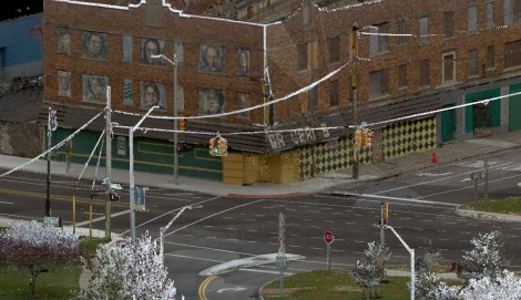
Figure 3: Mobile LiDAR dataset of roadway intersection colorized with high resolution imagery
The true “mobility” of the system has allowed for their system to be transported all over the world and mounted on various platforms, depending on the application. This type of mobility is made possible by having the IMU, LiDAR sensors, and GNSS all fixed on a rigid frame. By using this rigid frame, all of the units that make up the system are fixed in relation with each other. This has allowed SSI to operate their system from a range of platforms including SUVs, trucks, ATVs, hi-rail vehicles, and boats.

Figure 4: SSI Compact RaLi (Rail LiDAR) Mobile Scanning Unit
SSI caters their use of LiDAR and provides data solutions based on their client’s needs. Not all projects are alike and require various levels of detail, accuracies, and deliverables. Their goal is to look at the big picture and to provide the best value for the overall life cycle of a project. For some projects such as asset inventory or asset management, “fully-controlled” design engineering grade data is not always economically feasible. With the use of their RIEGL mobile scanning systems, SSI is able to provide “minimally controlled” datasets. When project requirements change or expand and the need for design grade data accuracies arise, SSI is able to fully control the scanned area and reprocess the data. This way, all of the data previously scanned can be recycled and used for multiple engineering purposes in the future.
SSI is currently utilizing LiDAR for surveying, design-build/construction, utilities, bathymetric surveys, topography, displacement monitoring, tunnel surveying, and transportation/infrastructure such as rail mapping, as-built surveying, road surface measurement, GIS mapping and asset management, and to monitor construction sites and bulk material.

Figure 5: Mobile LiDAR dataset of roadway colorized with high resolution imagery
Types of projects that SSI is accomplishing with both of their MoLi systems include surveying for road designers, utility locations, airport design, complete asset management for DOT’s, municipalities, and private entities, highly detailed digital terrain models (DTM’s), stringless paving operations, geographic information systems (GIS), and bridge underclearance determination.
One of their most notable projects is the Gordie Howe International Bridge (GHIB) project in Detroit, Michigan. This project was both state and nationally recognized by the American Council of Engineering Companies (ACEC). The overall goal of the project was to create and validate a comprehensive survey dataset to be used for the design and construction of the U.S. portion of the GHIB including approaches and toll plaza.
There were over 40 miles of roadway data that needed to be collected. Before the project could begin, there were several challenges and unique factors that needed to be considered including impacts on the motoring public, safety of the field personnel, the amount of data that was to be collected, and tight scheduling. To meet the project challenges, SSI utilized RIEGL mobile LiDAR to provide a 3D model of the accessible portions of the projects and also utilized other data sources from previous past projects including aerial LiDAR, aerial mapping, and conventional survey data. With this use of data fusion, SSI was able to create a fully controlled, dense dataset that has since been used downstream for multiple other purposes.

Figure 6: SSI MoLi (Mobile LiDAR) RIEGL VMX-1HA Mobile Scanning Unit
LiDAR allows SSI to provide clients with complete 3D data solutions in the most efficient way possible. Projects are requiring tighter timelines and a quicker turnaround of data. With the use of RIEGL mobile LiDAR, SSI is able to meet those demands and do so without sacrificing safety or accuracy.
SSI looks forward to working with both new and existing clients to find innovation solutions to meet the ever changing challenges facing the transportation industry.

Figure 7: Rail LiDAR dataset of roadway intersection colorized with high resolution imagery

Figure 8: Mobile LiDAR dataset of roadway intersection colorized with high resolution imagery

Figure 9: SSI VMX-250 system mounted on an ATV equipped with tracks in order to acquire greenbelt areas of the Detroit Metro airport

Figure 10: Mobile LiDAR dataset of airport taxiway colorized with high resolution imagery
We here at RIEGL appreciate working closely with SSI and look forward to our further successful partnership!
Pingback: Customer Spotlight: SSI — The RIEGL Newsroom | Surveying Solutions, Inc.·